


New Delhi, March 18
Heavy rains and gusty winds hit the northern states on Wednesday, with a few places in Himachal Pradesh and Jammu and Kashmir receiving snow.
The national capital Delhi also witnessed a turbulent weather in the evening as gusty winds, dust storms and thunderstorms, accompanied by rain, swept across parts of the city.
Meanwhile, the India Meteorological Department, in an X post, said it has issued “an orange warning for light to moderate thunderstorm with lightning and gusty wind activity along with light to moderate rain over Jammu region and Himachal Pradesh”, along with some other states.
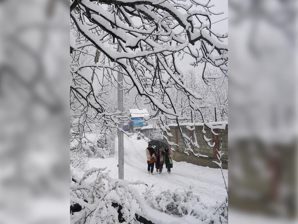
Some areas in the higher reaches of Kashmir received fresh snowfall on Wednesday, while rain lashed most parts of the Valley.
Pir Ki Gali in Shopian district and Sonamarg in Ganderbal district received snowfall, even as most mountains in the Valley — which have been receiving intermittent snow since Sunday — remained covered by layers of white.
The plains, including Srinagar, were lashed by rain, which continued till the last reports came in on Wednesday.
The Met department has forecast erratic weather in the Union Territory till March 20, with a possibility of intermittent light-to-moderate rain or snow at many places. It said a few higher reaches in the Chenab Valley and south Kashmir may receive moderate-to-heavy snowfall.
The weather office has predicted another wet spell from March 26-28 with light rain or snow at scattered places in the higher reaches. It has also forecast thunder and gusty winds with speeds of 40-50 kilometres per hour at a few places till March 20, with the possibility of hailstorms at isolated places.
In Himachal Pradesh, isolated places in the Lahaul and Spiti district received fresh snowfall, while rain lashed some districts.
Gondla in Lahaul and Spiti received 4 cm of snow, Kukumseri 3.6 cm, Keylong 3 cm and Hans 2.5 cm.
Among the districts that received rainfall, Manali recorded 14 mm of rain, followed by Dharamshala and Kangra 2 mm each, and Shimla and Jubberhatti 1 mm each.
The Met office in Shimla has issued an orange warning, predicting heavy snow and thunderstorms in the state in the next two days, even as it said the wet spell is likely to continue till March 24.
Lahaul and Spiti will continue to get heavy snowfall on Thursday and Friday, it said, adding that heavy rain, snow, thunderstorm with lightning, hail and gusty winds with speeds ranging from 40-60 kilometres per hour are likely at isolated places in five districts, namely Chamba, Kangra, Kullu, Mandi and Shimla.
The Met office said light to moderate rain or snow is very likely at most places of the state on Thursday and Friday, while light rain and snow is likely at isolated places of the state from March 21 to 24.
Delhi, which recorded a maximum temperature of over 33 degrees Celsius on Wednesday, ended the day with gusty winds, dust storms and thunderstorms accompanied by rain sweeping across parts of the city.
Wind speeds reached up to 68 kilometres per hour in some areas, following which the weather office issued an orange alert at 7 pm.
The Met office has issued a yellow alert for thunderstorms and rain in the next two days.
Rainfall activity intensified across the Delhi region till 8 pm, with CRPF Campus recording the highest precipitation at 11.5 mm, followed by Janakpuri at 10.5 mm.
Experts said a western disturbance has induced a cyclonic circulation over south Haryana, which triggered the rain and storm on Wednesday.
“From Thursday onwards, the system is expected to intensify over central Pakistan and adjoining parts of Punjab and Haryana, leading to further rainfall over the next two days,” Mahesh Palawat from Skymet told PTI.
Palawat added that the system is likely to bring additional pre-monsoon showers, thunderstorms and a possibility of hailstorms in isolated pockets. Temperatures are expected to drop to the mid-to-high 20s degrees Celsius due to the ongoing weather activity, but will rise again after the disturbance subsides.
In Rajasthan, Fatehpur in Sikar district recorded 7.5 mm rain, followed by 1.1 mm in Pilani and 1 mm in Sikar city.
The Meteorological Centre in Jaipur has predicted rain, gusty winds and isolated hailstorms in several parts of the state from Wednesday onwards.
It said due to the impact of a fresh western disturbance, a circulation system is likely to form over southwest Rajasthan and adjoining areas on March 18. The effect is expected to bring thunderstorms with wind speeds of 40-50 kmph and rainfall at some places between March 18 and 20, with chances of hailstorms at isolated locations.
The impact is likely to intensify on March 19 and 20, when parts of the Jodhpur, Bikaner, Ajmer, Jaipur, Bharatpur, Udaipur and Kota divisions may experience thunderstorms, strong winds and rainfall, with isolated hailstorms also likely.
Light rains were received at some places in Punjab and Haryana, leading to a drop in maximum temperatures by a few notches below normal.
According to the local Met office, Amritsar and Pathankot received 0.5 mm and 4.5 mm of rain, respectively, while rainfall activity was also witnessed in Patiala.
In Haryana, Hisar, Narnaul, Bhiwani and Charkhi Dadri received 1.9 mm, 4 mm, 0.5 mm and 2 mm, respectively.
PTI
New Delhi, July 3 Rashtriya Swayamsevak Sangh (RSS) General Secretary Dattatreya Hosabale on Friday said…

Ayodhya, July 3 The Special Investigation Team probing the alleged embezzlement of donations at Ayodhya’s…

Wellington, July 3 Prime Minister Narendra Modi is set to visit New Zealand next week…

Chandigarh, July 3 Thousands of families living in unauthorised colonies across Punjab could soon find…


